by Andy Green, November 2008
 Verneuk (pronounced FUR-NEE-OOK) Pan is located in the Northern Cape Province of South Africa and is something over 20 miles long. It is famous for being the site of Malcolm Campbell’s ill-fated bid for the World Land Speed Record in 1929.
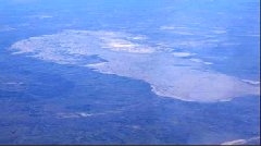
Left: Verneuk Pan, aerial shot from the NW – my first view of the famous LSR site.
Imagine their disappointment when, after Campbell’s team had made the Herculean effort to get to S Africa in early 1929 with the Blue Bird car and all the support equipment, the record jumped to 231 mph (thanks to Henry Segrave and the Golden Arrow, running in Daytona) just before they were ready to run… and they knew that Blue Bird was not capable of 230+ mph! The world 5 mile and 5 km records that Campbell subsequently set were scant consolation for missing out on the ultimate prize.
 The survey visit to S Africa was helped enormously by Ray Wakefield, a Speed Record enthusiast himself, and his close friend (and helpfully a civil engineer) Mike Miller. Their assistance, and the terrific Afrikaner friendliness and hospitably of the Northern Cape, meant that we got a lot done in just 24 hrs.
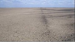
The first surprise was that Campbell’s Track is still clearly visible, almost 80 years later. Unfortunately, that’s mostly because of all the stones that they had to clear out of the way – the whole Pan is covered in them.
Right: The edge of the old 1929 Campbell Track, where the stones had to be cleared away for Blue Bird
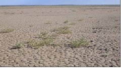
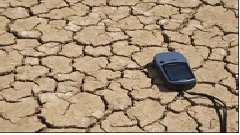
 The longest useable section is at the W end of the Pan, where the old Campbell track can still be seen. The whole Pan is covered with a light scattering of black shale stones, with concentrations of stones at regular intervals over the whole area. There is also extensive sparse vegetation on the surface – not something I’ve seen on other playas. The surface is a very hard smooth alkali playa (despite the vegetation), only spoiled by the stones.
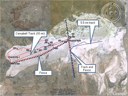
Left: GPS tracks (Red/Blue lines) and waypoint markers showing the surveyed areas. The dotted black lines indicate significant fences.
A north-south road runs across the middle of the Pan and several fences dividing up the area. Campbell created a 10-mile long track by preparing the surface at the Western end of the Pan, which we drove several times. We also looked at a shorter track (5.5 mi) on the E side of the Pan which had also been artificially prepared and was the best surface we saw.
All the other requirements for an LSR track are there – great weather factor, good road and air access, accommodation, communications with the outside world, even a hard, smooth surface on the Pan. The big problem is the stones, though – it would take a tremendous effort to repeat the preparations that Campbell undertook for his 90-ft-wide track, but over an area 50 times the size in order to meet BLOODHOUND SSC’s requirements.
Verneuk Pan is not what we need to run the Car on, without a huge amount of work.
We’ll keep looking.